32 land for sale in Frome
For Sale Land Isle Of Anglesey Isle Of Anglesey DS91123709
 View photo
For Sale Land Isle Of Anglesey Isle Of Anglesey DS91123709
Isle of Anglesey, Isle of Anglesey Map
...landdona with Planning Permission for a Stunning New Build. A rare opportunity to acquire a spacious plot in the picturesque village of Llanddona, just moments from the stunning Anglesey coastline. This desirable site comes with planning permission f...
- auction

For Sale Land North Yorkshire Calderdale DLS91831523
 View photo
For Sale Land North Yorkshire Calderdale DLS91831523
North Yorkshire, North Yorkshire Map
StrapLineAuction - 19/08/2025A broadly rectangular site, previously arranged as a four bedroom house and now part demolished, with planning permission previously approved and now expired for the construction of four, three bedroom townhouses,...

Plot Commercial
 5 pictures
Plot Commercial
BA5, Nr Wells Map
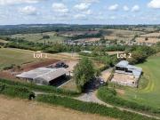
...land is also available by separate negotiation. Situated in a superb rural yet accessible position with an enviable elevated plot providing views west towards Wells. Lot 1 - Situated to the west of Jack’s Lane currently comprising the steel frame bar...
- garden

Plot Commercial
 2 pictures
Plot Commercial
BA14, Trowbridge Map
...land that is located on the northeast side of Yarnbrook and fronts the main A350, which provides links to Westbury and Melksham. The topography of the land is level but due to inactivity it is currently very overgrown, no flood risk has been identifi...

Plot Commercial
 10 pictures
Plot Commercial
BA11, Chantry Map
...Frome. The site currently comprises of a selection of redundant barns, it will be the responsibility of the purchaser to clear any remaining structures. The topography is level, and access is via a shared driveway. Cooper and Tanner residential offic...
- parking

Plot Commercial
 9 pictures
Plot Commercial
BA3, Radstock Map
...Landscaped gardens with hedges and trees to most plots and on plot parking. Scheme layout and housing mix as illustrated on the plans and summarised within the images. Access is taken via Chapelfield a residential cul-de-sac and will complement the a...

Plot Commercial
 6 pictures
Plot Commercial
BA3, Radstock Map
...land measuring approx. 0.19 acres located in the town of Radstock. This parcel of land is owned by St Peters Church and they have permission from the Diocese to obtain bids for the potential development for up to two dwellings. Currently access to th...

Plot Commercial
 9 pictures
Plot Commercial
BA6, Glastonbury Map
...land with an access gate in the northeast corner off Lowerside Lane just off the A39 where the site access is proposed. There is another access gate in the southwest corner off Common Moor Drove. To the southeast of the site are allotments and the re...

4 Bedroom Plot Commercial
 7 pictures
4 Bedroom Plot Commercial
BA7, Castle Cary Map
...land on the outskirts of the wonderful town of Castle Cary. Consent was granted on 24th May 2024 for the demolition of the range of agricultural barns and for the erection of a detached dwelling on a different part of the site as shown on the site pl...
- 4 rooms
- terrace

Land Surrey Surrey 91015594
 View photo
Land Surrey Surrey 91015594
Surrey, Surrey Map
...land of approx half an acre with gated access from St Piers Lane, Lingfield.This amenity land could have a variety of uses, grazing, equestrian, dog walking or long term development potential ( subject to planning permission ).Call the auctioneer for...

For Sale Land Lancs Lancashire DS92693441
 View photo
For Sale Land Lancs Lancashire DS92693441
Lancs, Lancs Map
...land with planning permission passed for four detached dwellings. Full application to view on Wyre Borough Council. 20/00729/FUL Council Tax Information: Band To be confirmedAgent NoteIn order to purchase a property in the UK, all estate agents are l...

